| Region | instruments | Find the data you want via calendars, lists or a map: | ||
|---|---|---|---|---|
| Shelf | ADCP+ADV | Calendar | List | 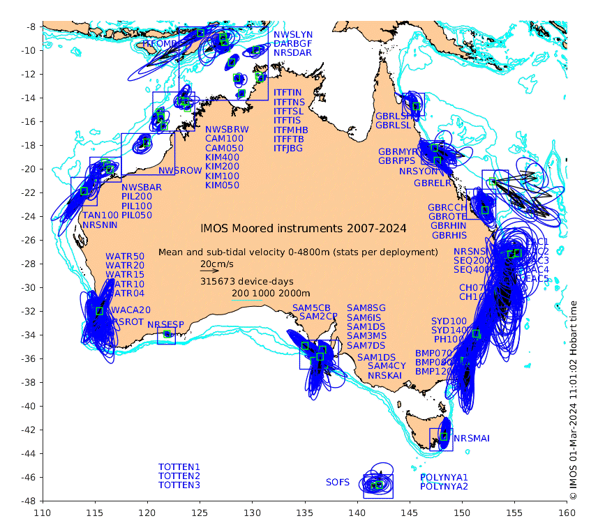 |
| Deep (ITF+EAC) | ADCP | Calendar | List | |
| Deep (ITF+EAC) | ADV | Calendar | List | |
| Southern Ocean | ADCP+ADV | Calendar | List | |
The overview map is your entry point to a series of maps showing a few properties of Australia's ocean currents: mean (all-time, annual and seasonal), standard deviation for various layers and time-windows, and tidal harmonics for the depth-average flow.
The detailed data from all individual instrument deployments is plotted in two ways. Both are reachable via the maps, calendars and lists:
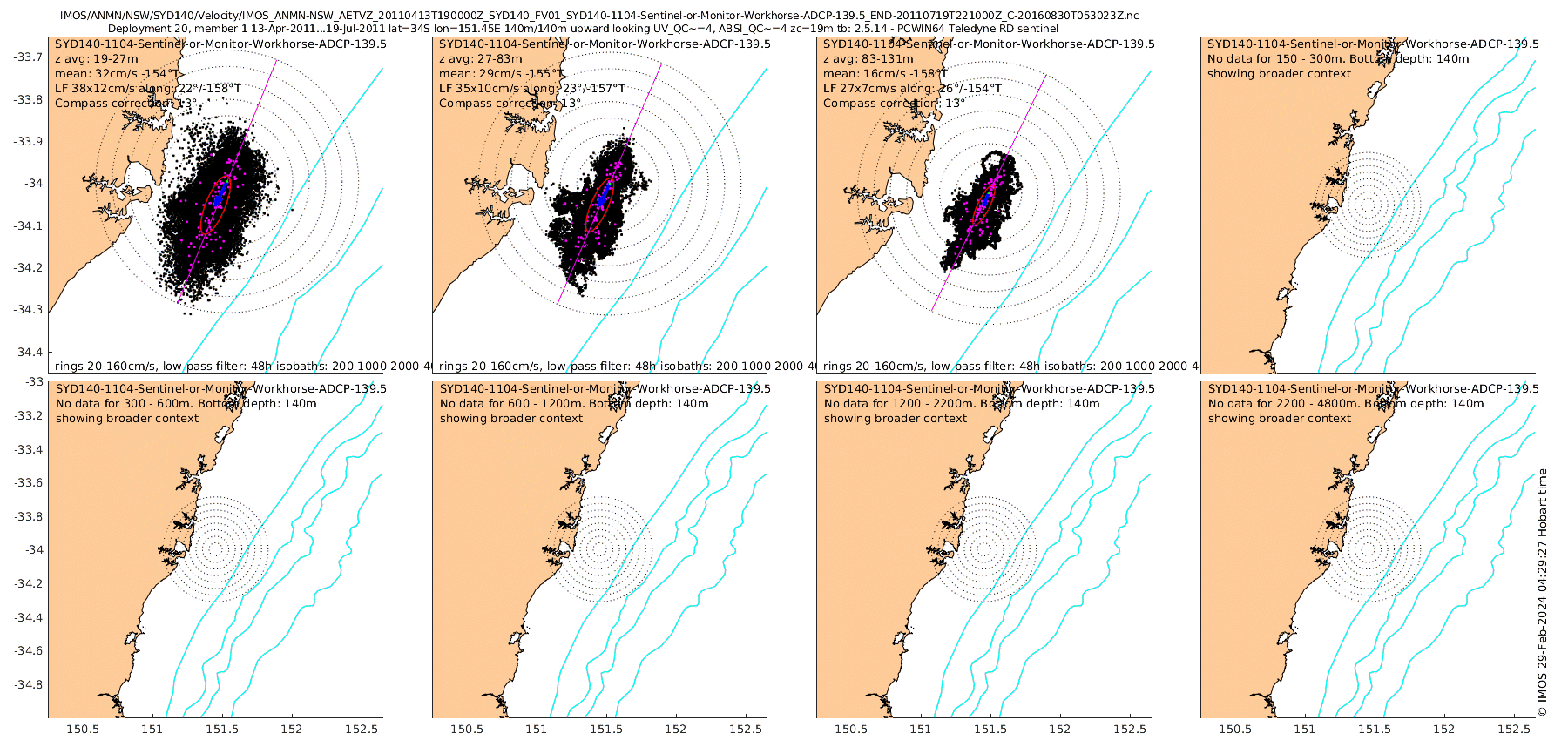
| multi-depth-layer map views of the velocity (with and without tides) | depth-time plots of velocity (resolved along subtidal major and minor axes), backscatter, depth and temperature |
|---|---|
 |
 |
29 February 2024 An update of the Shelf Array, taking the tally of individual current meter deployments for that array from 1142 to 1198. Many of the new files are for the Sydney 'Ocean Reference Station' ORS065 just off Bondi. (our ref: P46)
14 September 2023 An update of the Shelf Array. The tally of individual current meter deployments is now 1142+96+186+21 = 1445 for Shelf, Deep(ADCP), Deep(ADV) and Southern Ocean arrays, respectively. A minor bug was fixed. Images with hotspots are now more precisely located (so what you click is what you get). (our ref: P44)
9 June 2023 An update of the Shelf Array. The tally of individual current meter deployments is now 1111+96+186+21 = 1414 for Shelf, Deep(ADCP), Deep(ADV) and Southern Ocean arrays, respectively. Also, seasonal (e.g. multi-summer) means were added to the maps of all-time and annual-mean currents. NB: in the course of this upgrade a bug was fixed - the numbers of device-days listed on those plots are now correct. (our ref: P43)
15 Feb 2023 An update of the Shelf Array, now with the Signature ADCPs reprocessed to include Height_Above_Sensor (see previous lists of Data File Issues). The tally of individual current meter deployments is now 1087+96+186+21 = 1390 for Shelf, Deep(ADCP), Deep(ADV) and Southern Ocean arrays, respectively. (our ref: P42)
24 Nov 2022 A major update of the deep water array, adding both the 2019-21 and 2021-22 deployments. The tally of individual current meter deployments is now 1039+96+186+21 = 1342 for Shelf, Deep(ADCP), Deep(ADV) and Southern Ocean arrays, respectively. (our ref: P40)
28 Sept 2022 A routine update of the shelf array. The tally of deployments is now 1039+67+134+21 = 1257 for Shelf, Deep(ADCP), Deep(ADV) and Southern Ocean arrays, respectively. (for ref: P37)
31 March 2022 A routine update of the shelf array. The tally of deployments is now 999+67+134+21 = 1217 for Shelf, Deep(ADCP), Deep(ADV) and Southern Ocean arrays, respectively. (for ref: P35)
21 August 2021 A mostly-routine update focussing on the shelf array. The tally of deployments is now 963+67+134+21 = 1181 for Shelf, Deep(ADCP), Deep(ADV) and Southern Ocean arrays, respectively. This update includes data from 5 new sites in the NW in addition to recently-uploaded data elsewhere.
11 March 2021 A mostly-routine update focussing on the shelf array. The tally of deployments is now 898+67+134+21 = 1120 for Shelf, Deep(ADCP), Deep(ADV) and Southern Ocean arrays, respectively. This update corrects a minor error (introduced at the previous update) with some of the tabulated tidal constituents.
16 Nov 2020 As well as now including the 4th deployment of the EAC array, the Deep Water Moorings data set has a new address at the AODN. The tally of deployments is now 875+67+134+21 = 1097 for Shelf, Deep(ADCP), Deep(ADV) and Southern Ocean arrays, respectively.
11 Feb 2020 This week's update and re-read extended the data base further into 2019. The tally of deployments is now 841+53+110+19 = 1023 for Shelf, Deep(ADCP), Deep(ADV) and Southern Ocean arrays, respectively.
27 Sep 2019 This week's update and re-read extended the data base into 2019, while netting several reprocessed files for PPS and HIS. The tally of deployments is now 815+53+110+19 = 997 for Shelf, Deep(ADCP), Deep(ADV) and Southern Ocean arrays, respectively.
26 Apr 2019 This week we performed a re-read of the AODN archive after learning that the time vector in the files is NOT a record of the central times of the averaging intervals, but the BEGINNING times. To get the central time you have to add half of the averaging interval. In some files produced by recent versions of the toolbox, the TIME variable has an attribute seconds_to_middle_of_measurement (abbreviated here to 'shift') so you can do this. For other files, however, this information is missing (see the new columns headed 'dt av shift' in the tabulations linked above, e.g. for the shelf array). For short averaging intervals (av=1 or 2 minutes) this is not a big problem, but for instruments that were set to do longer averaging intervals (20-60 minutes), it is. In all cases, users wanting to analyse the very high-frequency spectral components will want to know the averaging interval (as well as the sampling interval), so we hope that a future re-process of the raw data will produce new files with 1) TIME being the center of the averaging interval (and confirm this is the case), 2) the averaging interval included, and 3) the number of pings averaged during that interval. This week's re-process also includes a minor bug fix that previously affected the 'dt_start' and 'dt_end' columns of the tables. There are now more zeros in those columns, indicating correspondence of the dates in the filenames with either the range of the time vector, the period of good data, or both.
21 Jan 2019
Our latest regular re-read of the data archive at AODN found 766+54+110+19=949 data files for the Shelf, Deep(ADCP), Deep(ADV) and Southern Ocean arrays, respectively (up 145 from 668+39+82+15=804 in May 2018). Navigation around the web site has also been improved.
ADCP - Acoustic Doppler Current Profiler. This measures the velocity of the water at a range of distances (10s to 100s of meters) from the device. The ANMN and DWM facilities have used several types: the RDI Workhorse, RDI Continental and Nortek AWAC units, all deployed as upward- or downward-looking units, either rigidly on the bottom, or in taut moorings.
ADV - Acoustic Doppler Velocimeter. This measures the velocity of the water just at one point very close to the device.
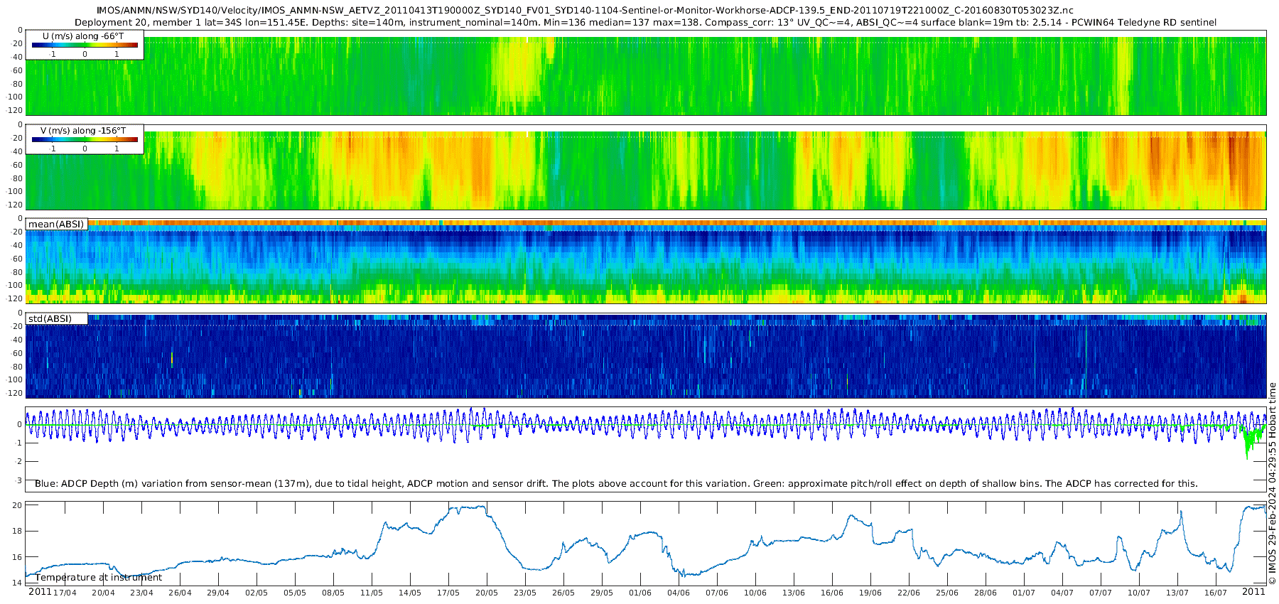
U, V - Current velocity components along orthogonal axes. These estimates are at a number of equi-spaced vertical distances from the ADCP, i.e. the manufacturer's software has taken the tilt of the unit into account. For ADCPs on short mooring lines (e.g. those of the Shelf Array) that do not undergo large vertical displacement, these data can be used directly to estimate velocity at a range of depth levels. This is what we used to do here but now we take the vertical motion of the ADCP into account in order to show velocity in depth coordinates.
ABSI - Acoustic Back-Scatter Intensity, without correction for the average range-dependent attenuation.
ADCP-T - Temperature at the depth of the ADCP.
ADCP-P - Pressure at the depth of the ADCP. This is a measure of both the mooring motion and the tidal elevation, and is shown to help trouble-shoot apparently spurious estimates of U and V. In some files this is a constant. Note that some instruments may suffer drift of the pressure data. Note also that moorings lines do stretch with time, so decreasing instrument depth is perfectly plausible.
ADCP-D - Depth of the ADCP. For some files this is missing, so we use ADCP-P, or the 'nominal depth' in the global attributes.
ADCP-tilt - A combination of the ADCP Pitch and Roll data, which are in the ADCP instrumental coordinate system.
SurfaceBinKnockdown - This is a diagnostic calculation of the approximate depth anomaly of the nominal surface bin resulting from the instrument tilt, also shown just for trouble-shooting purposes.
Surface blanking interval - ADCP velocity estimates are contaminated by side-lobe interference with the surface for a significant distance beneath the surface. The thickness of this affected layer is about 12% of the nominal instrument depth but also depends on the instrument acoustic characteristics (frequency, beam width, etc), the tilt and the sea state.
24 May 2018 Another re-read of the thredds server (including the Southern Ocean array for the first time) has netted 20 additional Shelf Array deployments and 15 Southern Ocean deployments. We have also implemented a new map-based way of navigating around the available data that also shows some basic statistics of the velocity data (such as mean, variance, tides, device-days).
15 Nov 2017 Another 8 months of new and/or re-processed Shelf Array and Deep Array data (including the 2nd EAC deployment) have now been added to our suite of plots. All 648 Shelf Array ADCP/ADV deployments, 39 Deep Array ADCP and 82 Deep Array ADV deployments have been reloaded from the THREDDS server to ensure that they are current. Users should note that some data files in the archive still have erroneous or missing location, timezone (AEST when metadata says UTC) or magnetic declination information. These files, and the identified issues are listed in the text index. The time corrections and magnetic declinations we have used are all listed in the updated [details table].
14 Mar 2017 Another year of new and/or re-processed ANMN data have now been added to our suite of plots. All 594 instrument deployments have been reloaded from the THREDDS server to ensure that they are current. Users should note that some data files in the archive still have erroneous or missing location, timezone (AEST when metadata says UTC) or magnetic declination information. These files, and the identified issues are listed in the text index. The time corrections and magnetic declinations we have used are all listed in the updated [details table].
19 Jan 2016 Another year of new and/or re-processed ANMN data (55 instrument deployments) have now been added to our suite of plots. All 494 instrument deployments have been reloaded from the THREDDS server to ensure that they are current. Some data files with erroneous or missing location, timezone or magnetic declination information have been corrected prior to calculation of tidal constituents. The applied time correction and magnetic declinations used are all listed in the updated [details table].
2 Feb 2015 Many new (especially ITF, KIM and PIL arrays) and/or re-processed (especially NRSKAI) ANMN data added. The updated [time index] page shows the magnitude of tidal residual currents after timing errors in a few data sets have been corrected.
29 Jan 2015 Tidal analysis has now been performed on all the ANMN velocity data (using the excellent uTide package). Summaries of the analyses have been added to the details table. See also the [tidal ellipse maps]. The [time index] pages now show the magnitude of the tidal-residual velocity as well as the total speed, graphicly demonstrating the very large variation that exists around the country of the relative importance of tidal and non-tidal velocity components.
21 Jan 2015 Non-ADCP current meter (Acoustic Doppler Velocimeter, or ADV) data are now shown in addition to ANMN and DWM ADCP data. We now also show the Satellite Remote Sensing Altimeter Calibration sub-facility SRS-ALT ADV data. The DWM ADV data are very numerous so they are plotted separately. Some are much deeper than the ADCPs so we have defined a new set of 8 depth-strata for windowing the data.
15 Jan 2015 We have just re-plotted all the ANMN ADCP data. 33 new or re-processed (using toolbox 2.3b) ANMN/NRS deployments have become available since 20 Sep 2014. The DWM deployments have all been re-processed (and now re-plotted) to correct an error in the processing of the backscatter data.
25 Sep 2014 Reprocessed SAIMOS data files (with corrected coordinate orientation information), and SA data for 2013 are now available from the IMOS portal. We have refreshed all our plots, which now show better alignment of the flow with bathymetry. We also looked a bit more closely at the consistency of the metadata and tabulated some diagnostics. See the new [details] link at the top of the text index page.
29 Aug 2014 Re-plotted all the ANMN velocity data. What's new:
OceanCurrent news item launching this section (April 2013), with discussion of some early highlights
National Mooring Network (a.k.a. 'shelf array')
Deep Water Moorings (a.k.a. 'deep array')
AIMS moorings website